- HOME
- PRODUCTS & SERVICES
GIS/GPS in Smart Cities/Transport METRIS — Big Data in Metro Transportation METRIS LiveQ: Real-time Truck Queues METRIS — Port Performance METRIS — GPS Tracking METRIS — Transport Planning Advanced GIS Analytics/Algorithms Transport Research Error Modeling Conflation GIS in Retail CLEO — Location Optimization Trade Areas Gravity Models Location-Allocation Models Enterprise GIS Strategic plan & cost-benefit analysis GIS Data Modeling GIS in Security Critical Infrastructure Protection Emergency Preparedness
- RESOURCES
News & Commentary METRIS News & Press Reports Light Technical Geography 80-20 (nuggets for adults) Geography Kids' Hangout Technical GIS Publications METRIS Publications Associated projects NCRST VITAL
- ABOUT
Getting Started with GPS—Equipment
Val Noronha | The Geography 80-20 collection
The basic outputs of a GPS are
- latitude and longitude, ±10 m
- altitude, ±30 m (pretty coarse)
- speed, ±1 km/h (very good) with Doppler
- heading (direction, 0-360°)
- date and time
- information quality (satellite positions and signal strength).
GPS equipment today integrates these items with other data sources and sensors: street/topo maps, traffic updates and routing functions, heart rate and pace cadence sensors, engine RPM reports, etc. We're not going to discuss all these variants. Our interest is in reading and interpreting the basic outputs above, which are common to all devices.
You can buy dedicated GPS equipment. Or you may look at the GPS
hardware you may own already: a car nav system or a smartphone.
We'll cover each of these here.
1. Single-purpose GPS receivers
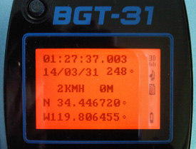
Genie BGT-31 displays basic outputs: time (UTC), date, heading (248°), speed (2 km/h), altitude (0 m), lat-long. There are several other report screens. BGT-31 is not WAAS enabled, so accuracy is not the best.
Limited in terms of mapping and general utility, dedicated
receivers display basic outputs, hence are useful for learning
first principles. The inexpensive ones at the top of the list
will get you started on a low budget. Those lower down offer
more, like integrated altimeters, electronic compass and even
cameras, and their features start to abut against tablet- and
computer-based functionality. Depending on your budget and tech
savvy, lower-end options plus creativity could serve you well.
| Series/Model |
Maps on board |
Review |
Origin |
Price |
| Egoman MG331 |
No | Not tested |
China |
$40 |
| Bushnell Back Track series |
No |
Not tested | USA |
$50+ |
| Genie BGT-31* |
No | Good |
Taiwan |
$150* |
| Magellan eXplorist series |
Some road/topo |
Good |
USA |
$100+ |
| Garmin eTrex/Oregon series |
Some road/topo |
Good |
USA |
$200+ |
|
*Genie BGT-31 was $150 some years ago, probably much lower now if you can find one — seems to be off the market. It includes Bluetooth and a logger (capacity depends on user-supplied SD card). |
||||
This is just a quick sampling of options and prices, both of which change rapidly. There are hundreds of devices available.
Some things to consider when buying:
- WAAS/SBAS enabled: makes a big difference in accuracy: ±3 m rather than ±10 m. The Wide Area Augmentation Service is a free satellite-based correction service available throughout the continental U.S. You don't have to do a thing to receive it, other than to pay an extra $10-20 for a WAAS-enabled receiver. If you travel overseas (Europe, Japan, China, India), look for the more generic Satellite Based Augmentation System; these overseas services may require special receiver settings.
- Maps on board: do you want streets for generic use, or topo
for hiking? If you're a hiker, on one hand you want to wayfind
with minimal electronic assistance. On the other hand, in an
emergency you want all the information you can get. Built-in
topos on these devices are rudimentary: often 1:100K, but
you can buy 1:24K versions.
- Battery life and charging arrangement: ideally lithium-ion
battery and USB charging, though there's something to be said
for ubiquitous AAs.
- Bluetooth: sends GPS data to another device (phone, tablet,
computer) for more advanced processing, mapping, etc.
- Data logging. Rather than a 200,000-point or whatever capacity, it's best when the device lets you insert your own SD card.
- Or the SD card can be used to upload and store better (1:24K)
topo maps.
- Physical: Rugged, weatherproof, lightweight, non-reflective
display, lanyard/carabiner.
- Firmware upgrades, certainly on more expensive devices.
- Connectivity to a computer or tablet, and software to feed data to a camera or photo files, and plot paths on a map or satellite image.
- A GPS does not sense cardinal directions unless you're in motion, walking at a brisk pace in an area with good reception. At low speeds it still outputs headings, which you have to learn to distrust. For those situations you may want a device that includes an electronic compass. Look for it in the spec sheet; a compass-like display does not mean that there's an electronic compass on board.
Sources: in addition to
Amazon and REI, look at semsons.com
2. Portable car navigation systems
Dominant brands: Garmin, Tomtom. Prices: $100+ minimalist, $200+ for better models with traffic and map updates
This is not designed as advice on acquiring a car nav system
for navigation. It's about coaxing your car nav system to output
raw GPS readings. Generally the point of a nav system is to
insulate you from the user-unfriendly language of lat-long,
presenting familiar addresses and maps instead. It tends to view
the world through the mask of motorable surfaces. So to display
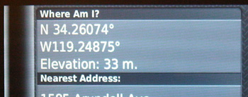
lat-long in a wilderness area, you'll need a Tools menu. On a
Garmin go to Tools | Where am I?
The issue of traffic updates just begs a couple of comments. Live
traffic information is
broadcast to these devices over a radio channel that's entirely
separate from the satellite-based GPS signal. These secondary
broadcasts to the device are of varying quality. One problem is
that they're 15 minutes old or more by the time they reach the
device, so when congestion is changing rapidly in the first and
last stages of rush hour, the device is not getting the best
data. At the beginning of rush hour, the ETAs tend to be optimistic,
and at the end of rush hour, they're pessimistic. Secondly, congestion/speed
sensors tend to operate on
freeways, not on service roads. You'll often find drivers
exiting a congested freeway on the advice of their GPS
navigators, only to find the alternate streets chock-a-block
too, because the broadcasters don't have the data showing those
roads turning into less viable choices.
3. Smartphones
A cellular system must know roughly where you are (±100 m) in order to deliver your signals. And under U.S. law they are required to be able to locate you if you call 911. Cell phones do not rely on GPS to do this. They know which cell towers your signals are reaching, and they can work out location from that.
Practically all of today's smartphones add a GPS chip for accuracy, for routing functions and to let marketers follow you around. But because that compromises your privacy, you have the option of turning the GPS on/off.
So it takes two things to use your smartphone as a GPS receiver. (1) Get an app that queries the phone's GPS and displays the outputs. Among the better apps, in terms of breadth of options, is Handy GPS. The basic version is free, and available for both iOS and Android. (2) Turn on the GPS. In iOS there are two relevant dialogs. At Settings | Privacy | Location Services, you turn the GPS chip on/off. Turning it off protects your battery and privacy. Under the main Settings page, you can turn location on/off for each app. Denying an app access to location does not save your battery, but it does protect your privacy.
Long-term, the smartphone is the most logical platform for advancing and integrating GPS functionality. For hiking, it may fail on ruggedness and battery life.

Tweet this URL
© Digital Geographic Research Corporation Contact us